Although groundwater exists everywhere under the ground, some parts of the saturated zone contain more water than others. An aquifer is an underground formation or permeable rock or loose materials which can produce useful quantities of water when accessed by a well. Aquifers come in all sizes and their origin and composition is varied. They may be small, only a few hectares in area, or very large, underlying thousands of square kilometres of the earth’s surface. They may be only a few metres thick, or they may measure hundreds of metres from top to bottom.
Many important Canadian aquifers are composed of thick deposits of sand and gravel previously laid down by glacial rivers. These types of aquifers provide water supply for many residents that live outside of urban centres that obtain their water supply from large rivers. To concentrate only on major (i.e., large) aquifers, however, is misleading. Many individual farms and rural homes depend on relatively small aquifers such as thin sand and gravel deposits of glacial or fluvial origin, as well as fractured bedrock intervals. Although some of these aquifers may not be significant, in total they make up a very important groundwater resource.
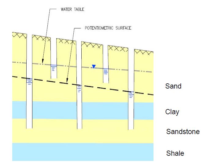
There are different types of aquifers that exist beneath the landscape. Many people are familiar with the term “water table”. This is the water that is first struck when we dig below the surface. The water table represents the surface of groundwater within an “unconfined aquifer” – unconfined because the upper surface is open to the atmosphere. This is exemplified by the upper dashed and dotted line shown in Figure 1. As such, the water table represents the surface at which the water pressure is at atmospheric pressure. The second type of aquifer is a “confined aquifer”. These aquifers are so-called because they are confined from above and below by sediments of lower permeability. These lower permeability layers isolate the aquifer from direct interaction with the atmosphere or other overlying and underlying aquifer intervals. The sealing nature of the confining layers results in an increased pressure of the water in the aquifer, such that is a well is drilled and installed into a confined aquifer, the water level in the well will stabilize above the top of the aquifer sediments. The resulting surface provided by numerous wells completed in the same interval over a given area is called a “potentiometric surface” (i.e., lower dashed line in Figure 1).
Aquifers are categorized as confined or unconfined, but there are many types of aquifers that are classified by where they are located in the earth and the material of which they are comprised. There are three types of aquifers: unconsolidated deposit aquifers, bedrock aquifers and quaternary aquifers.
![Figure 1: Confined and unconfined aquifers: This figure shows the two types of aquifers, confined and unconfined, within an impermeable bedrock basin. The dark blue layer between the aquifers is an aquitard [1].](https://waterportal.ca/wp-content/uploads/2015/04/Confined-and-unconfined-aquifers.jpg)
An unconsolidated deposit aquifer is an aquifer that is made up of loose sediment such as gravel and sand. These aquifers are close to the surface and are almost always unconfined. This type of aquifer is commonly found near rivers in a floodplain. Unconsolidated deposit aquifers are formed as the result of old rivers that no longer exist, by glaciers that have moved the sediment or by deposition at the bottom of a lake. The water in an unconsolidated deposit aquifer is directly connected to the surface water system.
Fast Fact: Groundwater makes up the largest source of useable freshwater in the world. A major aquifer like the Guarani aquifer in South America holds almost double the amount of water as major surface water reservoirs, such as the North American Great Lakes. In Alberta only 0.01% of groundwater is recoverable.
Source: Rivera, A. (2014). Canada’s Groundwater Resources. In print.
Bedrock is the hard rock that lies below all the sand, gravel and soil near the ground surface. A bedrock aquifer is an aquifer that is confined within hard bedrock layers. These bedrock formations tend to be comprised of thick alternating sequences of sandstone, siltstone and shale deposited in the foreland basin of the Western Canadian Sedimentary Basin over the last 100 million years (i.e., Cretaceous to Tertiary Periods).
Water can travel through porous bedrock, or through cracks, fractures and crevasses in the hard bedrock. In Alberta, 84% of groundwater wells draw from bedrock aquifers [2]. These aquifers are easily accessible in areas where the bedrock is near the earth’s surface, such as in southern Alberta.
In Alberta, there are three types of bedrock aquifers: carbonate aquifers, sandstone aquifers, and fractured shale aquifers.
Carbonate aquifers are made of rocks such as limestone and usually contain saline water. Sandstone aquifers are made of sandstone, a highly permeable rock, and can contain either saline or freshwater. The largest aquifer in Alberta, the Paskapoo Aquifer, is a sandstone aquifer. One third of groundwater wells in Alberta are located in the Paskapoo Aquifer [3]. An estimated 200,000 wells have been drilled into this southern Alberta formation, with about 70,000 considered active (GoA 2010). By international standards, the Paskapoo Formation would not be considered a “classic aquifer system” as the yield capability is restricted by its dominant fine-grained lithology and highly variable spatial-character with respect to sandier and more permeable intervals.
Shale is a rock that is similar to sandstone, but is less permeable. For shale to be an aquifer, it must be fractured, or cracked, so water can flow into it. Fractured shale aquifers are relatively rare in Alberta. The wells that draw from this type of aquifer do not produce as much water.
A modern day analogue of the type of depositional environment responsible for bedrock aquifers exists in the Columbia Valley of the East Kootenays. There, the Columbia River winds its way from the headwaters of Columbia Lake northward towards Golden through a series of wetlands, depositing granular materials within distinct channels in stacked sequence or as over-bank deposits of limited extent. As such, the low energy depositional environment is prone to the accumulation of fine-grained sediments (silt and clay) which interrupt otherwise continuous and connected sandy intervals.
The other bedrock aquifers of Cretaceous age do supply, or have the potential to supply, large quantities of usable groundwater but are more prone to highly mineralized porewater due to interaction with higher salinity formations deposited in the Cretaceous sea that extended across Alberta at the time. Nevertheless, in areas where these bedrock formations come close to the surface, many residents and businesses in Alberta access the water supplies contained within for personal or economic use.
Fast Fact: Most of the sand and gravel that lies on top of bedrock in Alberta was placed there by glaciers over 10,000 years ago!
Quaternary aquifers are aquifers that were created by glaciers. They are located between bedrock and the earth’s surface. These aquifers can be confined or unconfined. There are two types of quaternary aquifers: buried channel aquifers and alluvial aquifers.
Buried valley aquifers are confined aquifers that can be directly above bedrock or higher up in the rock layers. These are ancient valleys that are filled with permeable sand and gravel. Unconfined sand and gravel aquifers are located at the surface or near the surface. An alluvial aquifer is a specific type of unconfined aquifer which has a river flowing through it. The river is the main source of recharge. Quaternary aquifers generally contain freshwater.
Lying beneath the surface of Alberta is an intricate network of buried channels formed prior to the last continental glaciations of North America (the ancestral drainage network) or formed during the process of erosion by glacial melt-water formed during warmer periods.
During the last continental glaciation, up to four episodes of ice advance and retreat occurred in response to the varying climatic conditions. During each of these events, deposits of sand and gravel were laid down in various locations across the province as broad outwash plains, fluvial channels and lacustrine (lake) deposits. These porous and permeable intervals were then subsequently buried under less permeable deposits of till, thus forming confined aquifers. The depositional features of interest here are the buried channels, which host considerable quantities of water in the pore spaces of the sand and gravel deposits.
The known network of buried channels beneath Alberta is extensive across the Alberta plains area east of the foothills area (or deformed belt) of the Rocky Mountains.
The morphology and overall sediment compositions within each buried channel varies. Within each of these features resides quantities of groundwater that can be used to supply rural populations and associated economic activities including rearing of livestock, cropping, mining and oil and gas recovery. Some of these buried channels are currently accessed as supply sources to support such activities.
Alluvial aquifers in the province of Alberta comprise the unconsolidated sand and gravel deposits that we commonly see along existing river beds, the occasional road cut or sometimes in an excavated gravel pit. These granular deposits tend to possess very high permeability due to the presence of significant void space between the sand, gravel and silt grains. As such, these deposits can yield significant quantities of water and because these deposits are close to surface, the water quality tends to be fresh.
The majority of these deposits represent recent (within the last few thousand years) sediments deposited by water flowing across the landscape along relatively well-defined drainage ways. In some cases, these deposits have been buried under layers of sediment that were deposited by glaciers that advanced and retreated across the Alberta landscape during the most recent continental glaciations, which ended some 10,000 to 15,000 years ago.
Some areas of Alberta benefit from substantial accumulations of these materials, and in turn the potential to develop groundwater resources if needed. Because these deposits reside close to the surface, costs of developing groundwater from these intervals is greatly reduced.
Some concern is mounting with respect to the mining of these alluvial sand and gravel deposits for aggregate materials to support construction activities. Mining of the aggregate material from its natural resting place requires dewatering of the sediments, which can lead to adverse effects to nearby users or sensitive ecological receptors and groundwater dependant ecosystems. Removal of this material also diminishes the water storage capacity and can disrupt subsurface flow systems. Consideration of these effects is therefore needed when developing groundwater resources from alluvial aquifers.
From a groundwater quality perspective, alluvial aquifers are the most sensitive type of aquifer to influences on the landscape. Depending on the type, extent and thickness of sediments covering these aquifers, the application or spills of chemicals and leaking of septic systems can significantly affect the quality of groundwater over localized areas, sometimes referred to as point-sources, or very broad areas (non-point sources).
Fast Fact: Coal can also be an aquifer. Water can easily flow through the porous and permeable layers of coal in the rock layers.