In flood hazard mapping, some areas are indicated as being at risk for a 1-100 year flood. Flood mapping is used to illustrate risk in certain areas to allow municipalities and communities to plan for the possibility of flooding.
Frequently the meaning of 1-100 year flood is misinterpreted as meaning a flood will occur in the highlighted area only once every 100 years. 1-100 year is actually a statistical designation meaning that in any given year there is a 1% chance a flood risk area will flood. It is similar to rolling a 100 sided dice each year where the number “1” means the area will flood. Further, some areas have experienced more than one 1-100 year flood in the same year.
|
Recurrence interval in years |
Probability of occurrence in any given year |
Percent chance occurrence in any given year |
The same as rolling a 1 on a ____ sided dice. |
|
250 |
1-250 |
0.4% |
250 |
|
100 |
1-100 |
1% |
100 |
|
50 |
1-50 |
2% |
50 |
|
40 |
1-40 |
2.5% |
40 |
|
10 |
1-10 |
10% |
10 |
|
6 |
1-6 |
16.7% |
6 |
Every year there is a risk that the flood hazard area may experience a flood. These areas might not be affected by floods for decades, while some decades may see multiple floods or even more than one flood in a year. So why do multiple 1-100 year floods happen in short timespan? Sometimes the unlikely happens and the 100 sided dice rolls a 1 twice in a row. Other times it’s due to human influence on the watershed, or an initial assessment that did not have enough data.
The amount of time spent in an area identified as being at risk for flooding increases the likelihood of being impacted by a flood. The following table illustrates the likelihood of an identified area being affected by at least one flood over various periods of time.
|
Years |
Likelihood of a flood |
||
|
1-50 (2%) |
1-100 (1%) |
1-250 (0.4%) |
|
|
10 |
18.3% |
9.6% |
3.9% |
|
30 |
45.5% |
26.0% |
11.3% |
|
50 |
63.6% |
39.5% |
18.2% |
|
70 |
75.7% |
50.5% |
24.5% |
|
100 |
86.7% |
63.4% |
33.0% |
|
130 |
92.8% |
72.9% |
40.6% |
|
150 |
95.2% |
77.9% |
45.2% |
|
250 |
99.4% |
91.9% |
63.3% |
Historical records of river activity are often used to calculate the 1-100 year; however, changes to the river and riparian areas over time may influence present day river activity. A river that has had one or more dams installed, several kilometers of wetlands and riparian areas removed, or rapid urbanization will behave differently. It is possible that there is now a systematic error in the calculation vs modern day events. Figure 1 demonstrates the new designation given as more data is collected and re-evaluated by scientists.
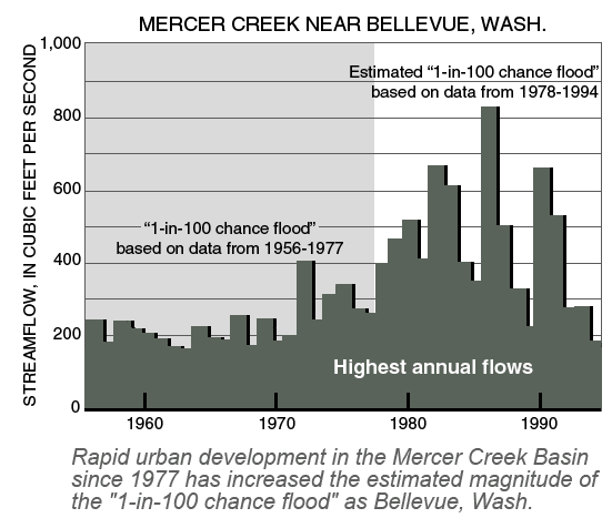
Increased urban development in the Mercer Creek Basin increased the streamflow and therefore changed the data to be considered [1].
If the historical data being used happens to represent a period where there was lower or higher number of floods than normal, then by random chance the initial calculation is incorrect.
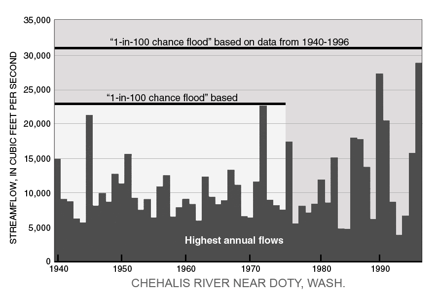
New data over time changed the expected magnitude of a 1-100 year flood in the Chehalis River. [2]
[1] Dinicola, Karen. (2014). The “1OO-Year Flood”. U.S. Geological Survey. Retrieved from http://pubs.usgs.gov/fs/FS-229-96/
We provide Canadian educational resources on water practices to promote conservation and sustainability. Our team crafts current and relevant content, while encouraging feedback and engagement.
The Canada WaterPortal is a registered charity, #807121876RR0001
We recognize and respect the sovereignty of the Indigenous Peoples and communities on whose land our work takes place.
© 2025 All Rights Reserved.