How Does Groundwater Interact with the Surface Environment?
Groundwater Interaction and Streams
As indicated by the hydrologic cycle, groundwater interacts with the surface water environment (including streams and rivers that drain the landscape, lakes and wetlands) that hold and store water that supports important ecosystems. Generally, the interaction with these systems takes place in three ways:
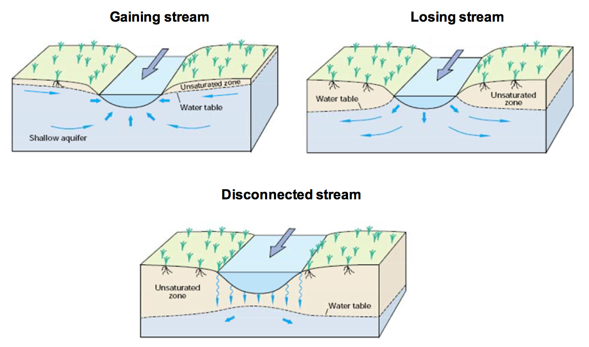
Streams gain water from inflow of groundwater through the streambed (gaining stream)
Streams lose water to groundwater by outflow through the streambed (losing stream)
Streams both lose and gain water from groundwater discharge along various reaches
This interaction is shown in the diagram above. For groundwater to discharge into a stream channel, the elevation of the water table in the vicinity of the stream must be higher than the elevation of the stream-water surface.
The opposite holds true for a losing stream. Losing streams can be connected to the groundwater system by a continuous saturated zone or can be disconnected from the groundwater system by an unsaturated zone.
Groundwater Interaction and Lakes
There are complex interactions between lakes and groundwater. The lake bed might feed the groundwater source, or the groundwater might feed into the lake. In some lakes, the direction of water flowing from the lake to groundwater (or groundwater to lake) does not change, but in instances the exchange might change depending on how much water is in the lake, how much precipitation there has been or the air temperature. The interactions between lakes and groundwater can vary tremendously. It is possible for a lake to receive groundwater in one part of the lake and lose water at another section of the lake.
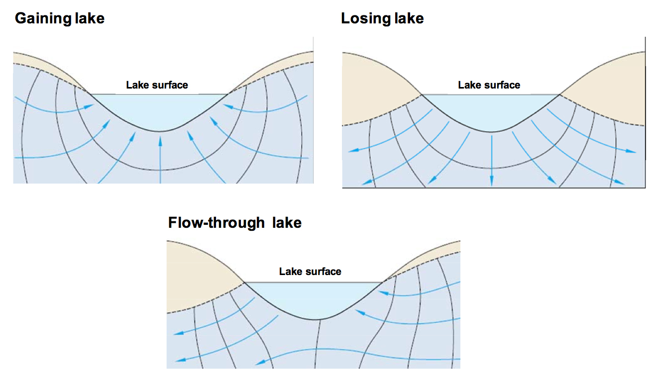
With respect to lakes, groundwater interacts with these features in three ways:
Groundwater inflow (gaining lake)
Seepage loss to the saturated zone (losing lake)
Groundwater inflow in certain parts and seepage loss from others (flow-through lake)
Although the basic interactions are the same for lakes as they are for streams, the interactions differ in several ways. The water level of natural uncontrolled lakes generally does not change as rapidly as the water level of streams.
Evaporation has the greatest natural effect on lake levels but water withdrawals, either through direct off-take of pumping of shallow groundwater nearby, can also effect a change in lake water levels by directly lowering levels or encouraging enhancing seepage loss.
Groundwater Interaction and Wetlands
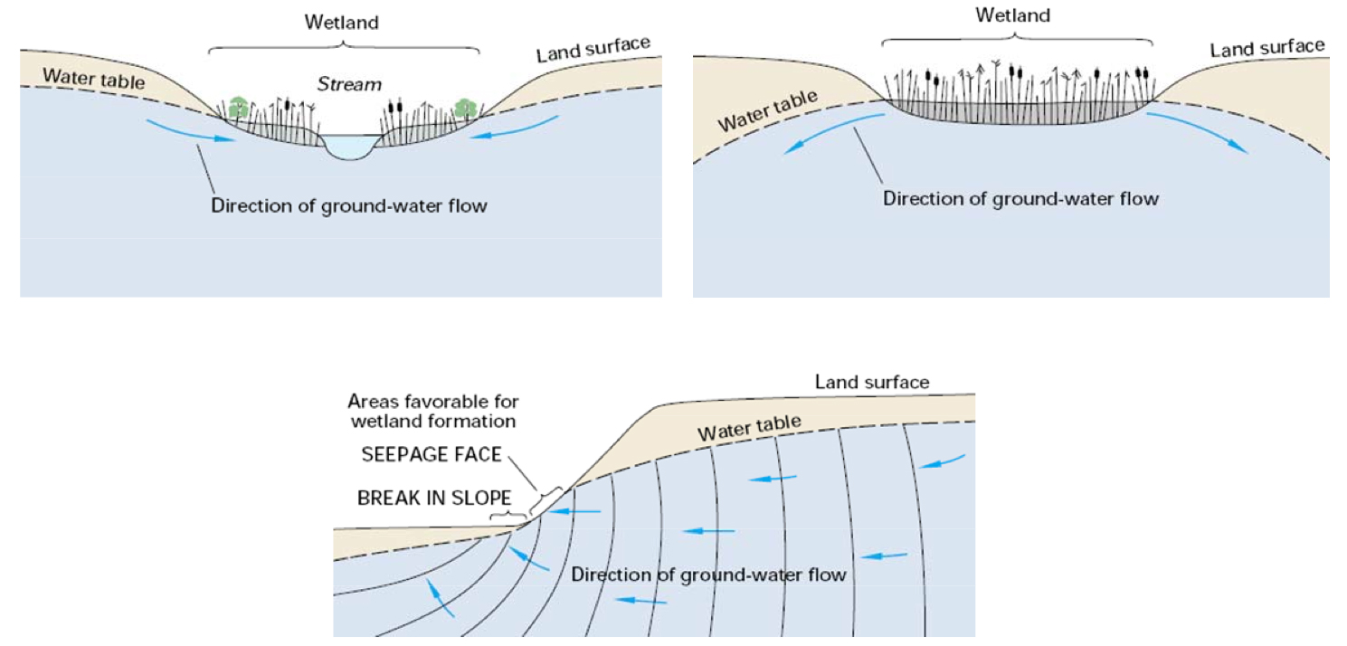
Wetlands exist in areas where groundwater discharges to the land surface or on landscapes that prevent rapid drainage of water from the surface.
Wetlands can receive groundwater inflow, recharge the groundwater system, or do both. Wetlands that occupy depressions in the land surface have interactions with groundwater similar to lakes and streams. Unlike lakes and streams, wetlands do not always occupy low points and depressions in the landscape. They also can be present on slopes (such as fens) or even on drainage divides (such as some types of bogs). The different types of wetlands include fens, bogs and swamps/marshes.
Wetland areas can also gain or lose water much like lakes. In areas of steep terrain, the water table sometimes intersects the land surface, resulting in groundwater discharge directly to the land surface.
If the discharge is a sustained flow, it is referred to as a spring. Conversely, if the rate of evaporation is nearly equal to the rate of delivery then it may only manifest as a wet patch, or seep. The constant source of water to these features supports the growth of wetland vegetation.
Groundwater Flooding
Groundwater flooding occurs when a large amount of groundwater comes to the surface quickly and causes flooding. When groundwater levels rise but remain underground, flooding can also occur. For example, basements that are deep and closer to a groundwater source can flood when the water levels rise.
Groundwater flooding can happen on its own, or at the same time as surface water flooding. When a river has high flows, some of this water goes underground. If groundwater levels are low, then this water is stored, and will slowly be released back to the river while the river flooding is ending. If groundwater levels are high, this water cannot be stored underground, so there is more water flooding the land.
Baseflow
Groundwater makes up the baseflow of a river. In the winter when there is not as much rainfall as there is in warmer months, groundwater contributes to streams and rivers, thus forming the baseflow (see Figure 1), which is the base amount of water in streams and rivers during low flow periods. During high flows on the surface, this interface may reverse and the river or stream will provide water to the groundwater system.
“Water Supply and Irrigation Papers of the United States Geological Survey” (1902) by Internet Archive Book Images has no copyright restrictions.