Flood designated areas are specific geographic areas that have been identified through flood mapping as flood zones. These flood zone areas, such as golf courses or agricultural land, are designated for flooding to further act as a mitigation method. Therefore, these designated areas can retain excess water that would otherwise flood a larger area and cause more extensive damage [1].
To avoid flooding in communities and downtown areas, flood designated areas are established to retain excess water and prevent flooding from entering other areas with higher costs. This mitigation method diverts water to areas where economic and social losses would be less than other locations [2].
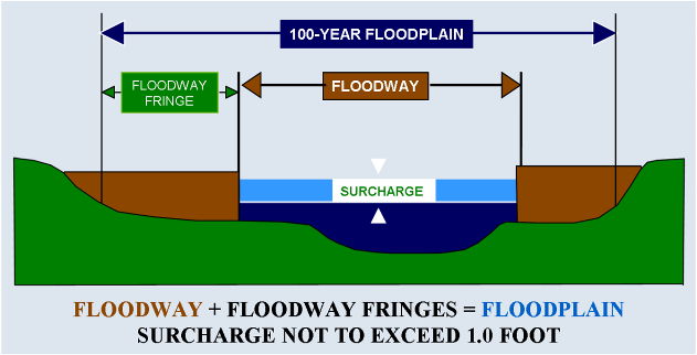
Designated flood areas do not currently exist in Alberta. While flood hazard maps show floodways and flood fringe areas, designated areas to divert flood waters are not yet in place.
Costs of implementing a flood designated area are mainly related to purchasing private property to be designated for flooding or compensating landowners, within the designated area, for property damage. Additionally, by flooding designated areas this approach limits damage to developments within a floodplain greatly reducing the cost of flood damages. For example, the Grand River Conservation Authority in Ontario has identified areas prone to damage either above or below $1000 in annual damages. This approach helped the Province to identify high risk and flood prone areas that should be kept clear of development [3].
While it does not a take long for a region to be determined a designated flood area, limiting and removing development can take a long time given property ownership and infrastructure. Furthermore, flood designated areas cannot be determined until flood maps are developed to show that an area is subject to flooding.
Flood designated areas are intended to be a permanent form of flood mitigation that makes room for the river by keeping the floodplain clear of infrastructure and development. If a major event occurs, however, where the natural channel of the river changes significantly, then it may be necessary to review flood designated areas and whether or not this land has been altered.
Creating a flood designated area requires that development and infrastructure is discontinued or built to withstand major flooding to ensure river flows can flood that area. The risk with this form of flood mitigation is that people are unable to live or work in these areas. This requires a legal framework to direct where designated flood areas are and how they are to be used [4].
Flood designated areas provide rivers with more room to move and change course as needed, although bank erosion and vegetation inundation can occur. For example, temporary reservoirs for a dry dam can be built to withhold flood waters temporarily which, can also lead to inundation and erosion of the surrounding ecosystem. Overall, floodplains provide an area for extra water to go further limiting pressure and stress on surrounding watersheds as well as the potential for flooding in developed areas [5].
Flood designated areas designed with rich root structures such as wetlands and forests are able to hold excess water and slowly release it downstream. This vegetation can be extremely helpful in times of drought [6].
We provide Canadian educational resources on water practices to promote conservation and sustainability. Our team crafts current and relevant content, while encouraging feedback and engagement.
The Canada WaterPortal is a registered charity, #807121876RR0001
We recognize and respect the sovereignty of the Indigenous Peoples and communities on whose land our work takes place.
© 2025 All Rights Reserved.