How Much Water Recharges our Province?
The Balance of Recharge and Use
A considerable amount of water recharges the subsurface annually through percolation and infiltration of precipitation and melting snow. This recharge represents the “renewable” part of our province’s groundwater resource, with water being added at variable amounts each year. Of course, some of this groundwater is removed for use as municipal, agricultural or industrial supply. Understanding the balance between input and output of groundwater is an important concept in the sustainable use of groundwater as a supporting resource for current and future development.
How much water recharges our province?
The volumes of groundwater in each aquifer type do not represent a static volume as water is constantly entering and leaving the subsurface through recharge and discharge processes. Recharge of the groundwater systems in our province is directly related to the amount of precipitation received in a given area, the associated terrain, the characteristics of the sediments blanketing the area, land use practices and the evaporative forces.
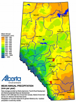
As is evident in the “Mean Annual Precipitation” chart (right), some portions of our province receive considerably more amounts of precipitation than others.
All things being equal, a region underlain by more granular materials, like sand, will tend to receive more recharge than an area underlain by lower permeability till or clay deposits, as the latter sediments act to impede the entry of water to the water table and underlying aquifers. Given the variability of precipitation received in our province, and changes in sediment types between, and within, the major basins, not all basins (or parts thereof) receive the same amount of recharge.
Previous estimates of recharge have been conducted by Alberta Environment to provide some context to our provincial water supplies (AENV 2009). Using the “baseflow separation” approach, the winter baseflow volume province-wide has been estimated to be about 4.8 billion cubic meters. Streamflow during the winter months is often used as an estimate for baseflow since most surface water and the near- surface hydrosphere is otherwise frozen and assumed to be non-contributing. Winter baseflow volume is then extrapolated into a 12-month volume to generate an annual average quantity. This led to the estimate of 14.8 billion cubic meters reported back in 2005.
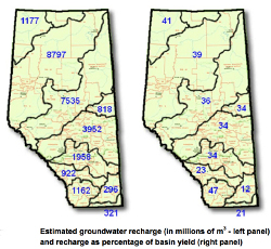
 Further accounting for increases in baseflow during the open-water season (when spring runoff and summer rains add to groundwater recharge and discharge rates) results in an average annual baseflow volume for the province of about 25 billion cubic meters. The second method of estimating recharge used interpretation of surface geology maps, and then estimating the recharge potential of the various soils and underlying geological formations resulting in a total provincial groundwater recharge volume of roughly 27 billion cubic meters per year. The chart (left) shows the distribution of recharge in each major basin of the province and the associated percentage of basin yield.
Put into perspective, anywhere from 25% to 45% of the surface water volumes generated annually in the province is provided by baseflow contribution, or discharge of groundwater to the rivers and streams. In some cases these contribution can be much higher (e.g., 68% of annual runoff for Jumping Pound Creek in the Bow Basin – AMEC 2009), underscoring the importance of groundwater to river flows and the preservation of aquatic habitat.
 It should be noted that the techniques of “baseflow” estimation of recharge, as opposed to the “baseflow separation” techniques, are varied in their approach. Nonetheless, the estimates provided indicate a range of between 15 and 30 billion cubic meters of recharge to the province per year, with the bulk occurring to the proportionally larger and wetter basins.
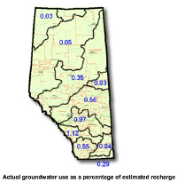
To provide additional context, a comparison of the actual amount of groundwater used in each major basin with the estimated amount of recharge has been made. The chart (right) shows the amount of groundwater used in each major basin as a percentage of the estimated average annual recharge received in that basin. It is evident that generally less than 1% of the estimated recharge that enters the basins each year is accessed and used, with the largest percentage occurring in the Bow River Basin at 1.12%, and the Red Deer River Basin at 0.97%.
Section 3: Use and Recharge
Module 1: How is our groundwater allocated and used?
Module 2: What are the differences between basins?
Module 3: How much water recharges our province?
Module 4: What are the anticipated trends in use?


